


Method
Pluvial flood index (PFI)
The core element of the AVOSS web demonstrator is the newly developed pluvial flood index (PFI). The PFI describes the risk posed by rapidly flowing surface water, which often runs off outside of rivers along small streams, depressions in the terrain, or paths and roads as a result of severe thunderstorms and can pose a danger to life and limb. The current warning system, which is based exclusively on precipitation amount and duration, does not provide reliable information about this hazard.
The PFI can be used both as a warning tool to assess the current pluvial flood risk (real events) and as part of awareness-raising (fictitious scenarios) to assess regional pluvial flood susceptibility. Both options are visualized in the demonstrator.
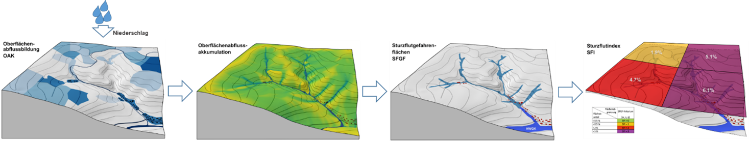
In order to identify the PFI, a modeling chain must be calculated—from precipitation data to hydrological runoff formation and hydraulic runoff accumulation to the identification of pluvial flood hazard areas (PFHA) and finally the classification of the PFI—as visualized in the figure below.
The criteria for identifying PFHA are as follows. All grid points with a maximum flood depth of ≥30 cm, a maximum flow velocity of ≥1.5 m/s, or a maximum specific discharge of ≥200 l/m*s are classified as potentially prone to pluvial flooding. The PFI is then classified based on the proportion of PFHA areas within a defined radius of each cell in the model area.
More information about PFI can be found on the AVOSS project homepage or in detail in a guide about the PFI devellopment
Precipitation & PFI
The event sums of the actual heavy rainfall events are based on calibrated precipitation radar data, which was provided at a temporal resolution of 5 minutes by the associated AVOSS project partner in the field of research and development, Kachelmann GmbH. The data largely corresponds to the data that is also visualized on the Kachelmann GmbH website as well as on our classified summer heavy rainfall events web application. The SRI is based on the KOSTRA heavy rainfall levels published by the German Weather Service in version 2020 (KOSTRA_V2020). The procedure corresponds to the approach described here .
The precipitation totals for the fictional scenarios are based on the spatial median (for Baden-Württemberg) of the precipitation values of various SRIs and duration levels based on KOSTRA_V2020, and are therefore spatially constant. In the demonstrator, SRI thresholds 3 (heavy), 5 (heavy - very heavy), 7 (very heavy), 9 (very heavy - extreme) and 11 (extreme) have been mapped for duration levels 30 min, 1 h, 2 h and 4 h. For further modeling, the respective total precipitation amounts are divided into 5-minute precipitation totals. The assumed temporal course of precipitation corresponds to a left-skewed Weibull distribution.
Calculation of surface runoff
Surface runoff is calculated using the physically based precipitation-runoff model RoGeR , which is also used in the heavy rainfall risk management system in Baden-Württemberg (SRRM-BW) .
In addition to the precipitation data described above, RoGeR also requires information on current soil moisture as event-specific input data. For real heavy rainfall events, the moisture conditions at the beginning of the event (based on a long-term water balance simulation created for the whole of Baden-Württemberg using the RoGeR_WB_1D water balance model) were used.
For the fictitious scenarios, three pre-moisture conditions were derived from the above-mentioned water balance simulation using a percentile approach. The "dry" pre-moisture option corresponds to the 10th percentile of the frequency distribution of the values of the usable field capacity (nFK) in the summer months; "medium" corresponds to the 50th percentile nFK and "wet" to the 90th percentile nFK. "
RoGeR outputs the so-called surface runoff (OA values, here 5 x 5 m spatial resolution) for each precipitation interval (5 minutes). This is the part of the precipitation that cannot infiltrate the soil (in heavy rainfall, usually due to excess infiltration).
Accumulation of surface runoff
In order to map the risk of flooding outside existing channel structures, it is essential to determine the spatial and temporal concentration of the surface runoff that is formed. Usually, 2D hydraulic models are used for this purpose, but these have the disadvantage of being relatively computationally intensive compared to other elements in the model chain, resulting in long calculation times. In AVOSS, an approach based on geomorphological flow accumulation was therefore developed to concentrate surface runoff, which allows flood areas and the criteria necessary for PFHA designation to be identified with minimal computation time.
The AccRo (iterative accumulated runoff) approach developed in AVOSS was applied to the PFI calculations shown in the demonstrator with a grid size of 5 x 5 m. In addition to the surface runoff values from RoGeR, static data on terrain morphology (DEM) and roughness are also included as input data. The roughness values are assigned to the various land use classes in accordance with the specifications of the SRRM-BW . The proportion of precipitation that falls on buildings is not taken into account in the current version of AccRo. Similarly, culverts or other passages cannot be taken into account in AccRo. Therefore, culverted channel sections in the DEM are made permeable again in the course of preprocessing.
In order to distinguish between fluvial floods and to avoid unrealistic discharge volumes due to uniform rainfall, the capacity of existing channels is assumed to be infinite in the case of fictitious scenarios with an accumulation area of more than 10 km². This means that no outflowing flooding can occur above this size of the contributing catchment area. In the case of real heavy rainfall events, this limitation does not exist due to the spatial limitation of real heavy rainfall events.
AccRo outputs spatial data on the maximum flood depth, the maximum flow velocity, and the maximum specific discharge. The results from AccRo can thus be used to directly derive the pluvial flood hazard areas and identify a corresponding PFI (see above). In addition, the parameters can also be used for damage scenarios.
KNN-based quasi-real-time heavy rain hazard maps
Due to the sometimes highly simplified assumptions and the rather low spatial resolution (here 5 x 5 m), AccRo can only be used to a limited extent for creating detailed, street- or building-specific flood maps, such as those found in heavy rain hazard maps (HRRMs). Therefore, detailed 2D hydraulic modeling will normally have to be used here.
However, due to the high computing time required for 2D hydraulic models, this can only be done independently of the specific event and only for a limited number of scenarios. As part of AVOSS, the use of AI to generate HRRMs in near real time was tested for individual test areas (see Emmendingen). For this purpose, a large data set of maximum flood depths and maximum flow velocities was generated using 2D hydraulic models for a large number of different heavy rainfall events. This was then used, together with the OA values entered into the 2D modeling, to train multi-layer artificial neural networks, which in turn can identify detailed HRRMs in near real time for any OA inputs. More information on the KNN approach used in AVOSS can be found here on the AVOSS project homepage.
Quantitative damage modeling
Identifying expected damage hotspots can significantly aid decision-making in an emergency. Against this backdrop, AVOSS performs a quantitative damage assessment at the reference level of the locations for the fictitious scenarios, which can be used to estimate the varying degrees of impact in the event of a potential incident and thus take precautions to minimize damage if necessary.
In the example of Emmendingen, a Bayesian network is used to quantify potential damage to buildings in the private residential sector as a result of flooding. In addition to building-specific factors, this approach also takes into account socioeconomic assumptions and the degree to which a municipality is prepared for heavy rainfall. With regard to flood parameters, the maximum flood depth and the maximum flow velocity are particularly important. For the location-specific damage estimates presented here, this information from AccRo is incorporated into the Bayesian network. More information on the damage modeling carried out in AVOSS can be found on the AVOSS project homepage .